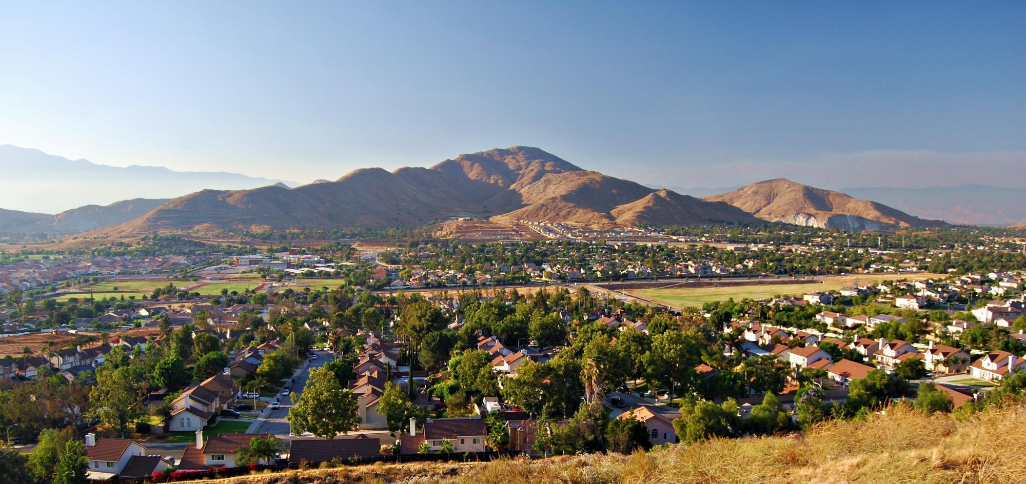
Mount Jurupa rising above Jurupa Valley

Outdoors

Camping near Jurupa Valley

Campgrounds and camping areas near Jurupa Valley on federal land, with which ones take reservations on Recreation.gov.

27campgrounds and camping areas
12 mito the closest
17within 30 miles
October–Maybest months

Good to know: Popular campgrounds book up months ahead on Recreation.gov; first-come sites fill early on weekends and holidays.

Closest picks

1

Prado Dam

12 mi southwest · US Army Corps of Engineers

This San Bernardino County Parks managed area is an oasis within one of the fastest growing areas of Southern California. Riverside County and the City of Corona also provide recreation facilities.

3

Applewhite Campground

18 mi north · USDA Forest Service

Located three miles north of the Lytle Creek Ranger Station, the campground provides an easy get-away. Trees surround the campsites and Lytle Creek flows across the street at Applewhite Picnic Area. Please use caution crossing the road.

Map of all 27 places

Map of 27 places loads as you scroll.

Within 30 miles (17)

12 mi southwest · US Army Corps of Engineers

Prado Dam

This San Bernardino County Parks managed area is an oasis within one of the fastest growing areas of Southern California. Riverside County and the City of Corona also provide recreation facilities.

  • Boating
  • Camping
  • Horseback riding
  • Picnicking
  • Water sports
  • Wildlife viewing

14 mi northeast · USDA Forest Service

San Bernardino National Forest

  • Biking
  • Camping
  • Climbing
  • Fishing
  • Hiking
  • Horse Camping
  • Horseback riding
  • Hunting

18 mi north · USDA Forest Service · Campground

Applewhite Campground

Located three miles north of the Lytle Creek Ranger Station, the campground provides an easy get-away. Trees surround the campsites and Lytle Creek flows across the street at Applewhite Picnic Area. Please use caution crossing the road.

  • Camping

22 mi northeast · USDA Forest Service · Campground

Dogwood

Dogwood Campground is a family-friendly facility located in the heart of the San Bernardino National Forest. All sites must be reserved to enjoy the area's scenic surroundings and plentiful recreational opportunities.

  • Boating
  • Camping
  • Fishing

24 mi south · USDA Forest Service · Campground

Falcon Group

Falcon Group Campground has three individual group campsites just off the scenic Ortega Highway in Southern California, which connects San Juan Capistrano and Temecula Valley Highway.

  • Biking
  • Camping
  • Hiking
  • Mountain Biking
  • Photography
  • Scenic Drive
  • Star Gazing
  • Wilderness

26 mi northeast · USDA Forest Service · Campground

North Shore (Ca)

North Shore Campground is a quiet place to camp, away from the hustle and bustle of nearby cities.

  • Boating
  • Camping
  • Fishing
  • Hiking

27 mi northeast · USDA Forest Service · Campground

Fishermans Group

This campground is Hike In only. Fisherman's Group Campground is a semi-primitive campground reached by a 2.5-mile hike into the mountains of southern California.

  • Camping
  • Fishing
  • Hiking
  • Horseback riding
  • Hunting
  • Wildlife viewing

28 mi northeast · USDA Forest Service · Campground

Tent Peg Group

Tent Peg Group Campground offers a semi-primitive location for an extended family or large group outing. The area provides easy access to many off-road vehicle trails.

  • Biking
  • Boating
  • Camping
  • Fishing
  • Hiking
  • Swimming
  • Wildlife viewing
  • Winter sports

29 mi northwest · USDA Forest Service · Campground

Coldbrook Campground

Coldbrook Campground offers 22 shaded campsites* at the intersection of Coldbrook and Soldier Creeks that are open year round.

  • Camping
  • Picnicking
  • Recreational Vehicles

29 mi northeast · USDA Forest Service · Campground

Crab Flats

Crab Flats Campground is an off-roaders paradise, with plenty of off-road vehicle trails nearby for both beginner and experienced riders.

  • Biking
  • Boating
  • Camping
  • Fishing
  • Hiking
  • Swimming
  • Wildlife viewing
  • Winter sports

29 mi northeast · USDA Forest Service · Campground

Green Valley

Green Valley Campground is located near Arrowbear in the San Bernardino National Forest in Southern California.

  • Boating
  • Camping
  • Fishing
  • Hiking
  • Swimming

29 mi northeast · USDA Forest Service · Campground

Shady Cove Group Campground

Shady Cove Group Campground is a beautiful place to camp within the Children's National Forest. It provides access to numerous trails and a lookout tower, with a climbing area nearby.

  • Biking
  • Camping
  • Fishing
  • Hiking
  • Ranger programs
  • Wildlife viewing

29 mi northwest · USDA Forest Service · Campground

Table Mountain (Angeles)

Table Mountain, just a short journey northwest of the Los Angeles metro area, provides a beautiful escape from urban life. Campers will find hiking, mountain biking, birding and countless other recreation opportunities.

  • Biking
  • Camping
  • Hiking
  • Mountain Biking
  • Scenic Drive
  • Wildlife viewing

30 mi northwest · USDA Forest Service · Campground

Appletree Campground

Nestled in a scenic canyon just off the Big Pines Highway, Apple Tree provides a scenic and relaxing destination for camping, hiking, picnicking and wildlife viewing.

  • Biking
  • Camping
  • Hiking
  • Mountain Biking

30 mi northwest · USDA Forest Service · Campground

Lake Campground

Lake Campground offers an excellent escape from the city, just a short drive northeast of the Los Angeles metro area.

  • Biking
  • Camping
  • Hiking
  • Mountain Biking

30 mi northwest · USDA Forest Service · Campground

Peavine Campground

Just northwest of the Los Angeles metro area, Peavine provides a scenic and relaxing destination for camping, hiking, picnicking and wildlife viewing.

  • Biking
  • Camping
  • Hiking
  • Mountain Biking

30 mi northwest · USDA Forest Service · Campground

Peavine Campground

6.100-foot elevation. 4 tent sites. No water. Vault toilets. Adventure Pass required for vehicles parked at campground. First come - first served. Usually inaccessable during the winter months. The area has heavy use during snow play.

  • Camping
  • Picnicking

30 to 75 miles (10)

32 mi northeast · Bureau of Land Management

Juniper Flats

Juniper Flats covers 101,272 acres of mixed public and private lands. Located between the Mojave Desert and the forests of the San Bernardino Mountains, Juniper Flats hosts a unique mixture of plants from both environments.

  • Biking
  • Camping
  • Hiking
  • Horseback riding
  • Hunting
  • Nature education
  • Off-highway vehicles
  • Photography

33 mi west · USDA Forest Service

Angeles National Forest

  • Biking
  • Camping
  • Fire Lookouts/Cabins Overnight
  • Hiking
  • Horse Camping
  • Horseback riding
  • Off-highway vehicles
  • Picnicking

43 mi north · Bureau of Land Management

El Mirage OHV Area

Remember your OUTDOOR ETHICS when enjoying your public lands. Please RECREATE RESPONSIBLY.

  • Biking
  • Camping
  • Hiking
  • Off-highway vehicles

49 mi east · Bureau of Land Management

San Gorgonio Wilderness

This wilderness is part of the eastern slope of the San Bernardino Mountains with topography rapidly changing from low, rolling foothills and canyons to steep, rugged mountains. Elevations range from 2,300 to 5,500 feet.

  • Camping
  • Hiking
  • Horseback riding
  • Hunting
  • Photography
  • Wilderness
  • Wildlife viewing

49 mi east · Bureau of Land Management

Sand to Snow National Monument

Remember your OUTDOOR ETHICS when enjoying your public lands. Please RECREATE RESPONSIBLY.

  • Accessible Swimming
  • Camping
  • Fishing
  • Hiking
  • Horseback riding
  • Photography
  • Wildlife viewing
  • Winter sports

53 mi northeast · Bureau of Land Management

Bighorn Mountain Wilderness

The north-central portion of this Wilderness area holds the rugged Bighorn Mountains and the eastern foothills of the San Bernardino Mountains.

  • Camping
  • Hiking
  • Horseback riding
  • Hunting
  • Nature education
  • Photography
  • Ranger programs
  • Wildlife viewing

54 mi northeast · Bureau of Land Management

Sawtooth Mountains Wilderness

The Sawtooth Mountains Wilderness now contains a total of 33,610 acres and is managed by the Bureau of Land Management. All of the Wilderness is in the state of California.

  • Camping
  • Hiking
  • Hunting
  • Photography
  • Wilderness
  • Wildlife viewing

55 mi northeast · Bureau of Land Management

Johnson Valley OHV Area

Click here for the latest information concerning upcoming military training and closures of the Shared Use Area. Overview Johnson Valley is a varied landscape for the off-highway vehicle driver.

  • Biking
  • Camping
  • Hiking
  • Horseback riding
  • Hunting
  • Photography
  • Recreational Vehicles
  • Wildlife viewing

58 mi northeast · Bureau of Land Management

Barstow

The Ord Mountain Route Network is south of Barstow and links the Stoddard Valley and Johnson Valley Off-Highway Vehicle Areas, also known as Open Areas. Travel within the network is limited to posted open routes.

  • Biking
  • Camping
  • Hiking
  • Horseback riding
  • Hunting
  • Nature education
  • Photography
  • Wildlife viewing

58 mi southeast · Bureau of Land Management

Beauty Mountain Wilderness

The Beauty Mountain Wilderness encompasses a total of 15,627 acres and is managed by the BLM's Palm Springs-South Coast Field Office .

  • Camping
  • Hiking
  • Horseback riding
  • Photography
  • Wilderness

Distances are straight-line miles from downtown Jurupa Valley. Listings come from Recreation.gov’s federal recreation database; check each official page for hours, fees, fire restrictions and closures before you go.

Get outside around Jurupa Valley

#shorts Jurupa Discovery Center video thumbnail

THINGS TO DO · YOUTUBE SHORT

#shorts Jurupa Discovery Center

A local activity Short shared by Abel Ortiz.

Watch on YouTube ↗

Around Jurupa Valley

Jurupa Valley Agricultural Field
Jurupa Valley Agricultural Field 2Z3lvs · CC0
Jurupa Valley Agricultural Field
Jurupa Valley Agricultural Field 1Z3lvs · CC0
Rubidoux fieldstone shed, Jurupa Valley
Rubidoux fieldstone shed 1Seauton , 14 August 2026 · CC BY 4.0

More outdoors near Jurupa Valley

Questions

Where is the closest place for camping near Jurupa Valley?

Prado Dam (US Army Corps of Engineers), about 12 miles southwest of Jurupa Valley as the crow flies. Next are San Bernardino National Forest (14 mi) and Applewhite Campground (18 mi).

When is the best time for camping near Jurupa Valley?

Based on Jurupa Valley’s average highs, October–May. Conditions at higher elevations can be much cooler.

Can I reserve a campsite near Jurupa Valley?

12 of the 27 places listed here take reservations on Recreation.gov; others are first come, first served.

Who manages these places?

Federal agencies including USDA Forest Service, Bureau of Land Management, US Army Corps of Engineers. Each listing links to its official page for hours, fees, closures and current conditions.

Jurupa Valley AI

Your Jurupa Valley local guide
Hey there!

I'm Jurupa Valley AI. Ask about neighborhood food, independent shops, local history or planning a visit.

AI recommendations may be inaccurate. Verify hours and prices. Questions are processed by Cloudflare. Privacy